|
 |
|
|
|
Join Gila's virtual tour of the just-opened
underground Second Temple period drainage channel up
to the first century AD pilgrim sidewalk and then
over to see the Solomonic wall and King Solomon's
royal gatehouse. |
|
|
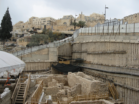
We start at the Givati parking lot below the Old
City's Dung Gate. In the photo below, we see
the ongoing excavations in relation to the Jewish
Quarter perched behind the Old City wall. The
Dung Gate is approximately to the right of the tall
black pole. |
|
|
|
 |
|
Photo: Gila
Yudkin |
|
"Givati" excavations below the
Dung Gate |
|
|
The ruins below have been dated to the first century
AD. Some of the original walls are preserved
to a height of two stories. It's possible that
they are part of a palace built by a convert to
Judaism named Helena who was the queen of Adiabene,
a kingdom on the upper Tigris River, in modern-day
Kurdistan. First century AD historian Josephus
Flavius wrote that Helena built "palaces" in the
City of David.
The rabbis recounted how she had come to Jerusalem
after her conversion to offer sacrifices in the
Temple and noted that she had contributed generously
to the poor. It's generally believed that
Queen Helena was buried in the Tomb of
the Kings. |
|
|
|
 |
|
Photo: Gila
Yudkin |
|
Second Temple period mansion
possibly belonging to Queen Helena of Adiabene |
|
|
|
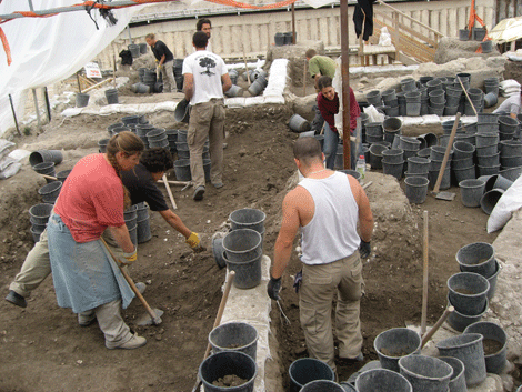
This excavation is ongoing and below you see a group
of volunteers digging with full energy. They
may have been supplied with packets of
vitamin
M! Note how many buckets they
expect to fill! They are digging directly
southeast of the ruins above, that is to the
left of the photo. |
|
|
|
 |
|
Photo: Gila
Yudkin |
|
Ongoing excavations in the old
Givati parking lot |
|
|
|
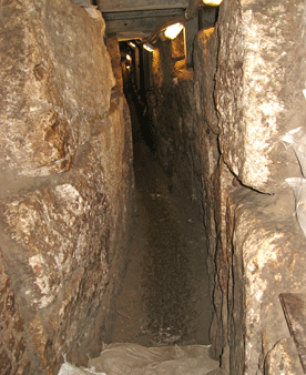
We descend into the Second Temple period drainage
channel that ran under the pavement adjacent to
Herod's Western Wall of the Temple Mount down the
Tyropean Valley to the
Pool of Siloam. The
drainage channel is walled on both sides.
Sometimes we walk along the original floor. In
some places we can still see the original stone
ceiling which is arched. Herod's construction
is absolutely amazing! |
|
|
|
 |
|
Photo: Gila
Yudkin |
|
Narrow Second Temple period
drainage channel which has just opened |
|
|
|
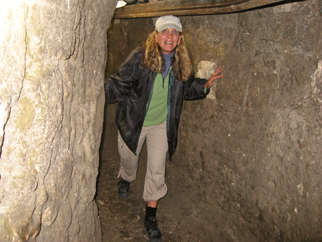
I'm now in the "wider" part of the channel.
Note that I am 5' 7" and have to duck in places to
avoid hitting my head. This adventure is
highly recommended for dwarfs! |
|
|
|
 |
|
Photo: Lee
Berlman |
|
Heading north in the underground
Herodion drainage channel |
|
|
|
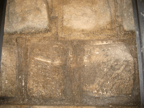
After ten or fifteen minutes we see the huge
Herodion masonry "under" the Herodion sidewalk,
outside the Temple Mount's western wall, under
Robinson's Arch. The "bellies" of these stones
are not as smooth as the ones we see by the
south-west corner of the wall. |
|
|
|
 |
|
Photo: Gila
Yudkin |
|
Herodion stones along the Western
Wall, under the Herodion sidewalk |
|
|
|
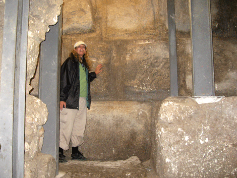
I am standing by the southern part of the Western
Wall, way down under Robinson's Arch. Note the
massiveness of the Herodion building. |
|
|
|
 |
|
Photo: Lee
Berlman |
|
Standing under the first century
AD sidewalk alongside the Western Wall |
|
|
|
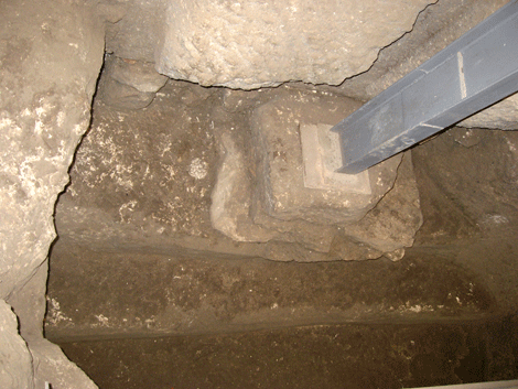
A mikveh or ritual bath alongside Jerusalem's
ancient drainage channel challenges the conventional
archeological belief that Herod built the wall in
its entirety. It's now thought that the
construction was completed at least 20 years after
Herod's death in 4 BC. Four Judean coins
dating to 17-18 AD were found near the mikveh.
No wonder John quotes the Jews as saying "This
temple has been under construction for 46 years, and
will you raise it up in three days?" (John 2:
20) |
|
|
|
 |
|
Photo: Gila
Yudkin |
|
Ritual bath where four Judean
coins dating to 17-18 AD were found |
|
|
|
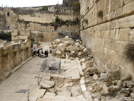
Now we've reached the end of our underground tour
and as we exit, we see a Bat Mitzvah in progress.
Note the cage in the middle of the photo below --
that's where we exited from the underground drainage
channel. In the middle of the photo we can
grasp the complete width of the first century
sidewalk, as we see the curbstones on both sides.
If you look to the right of the photo, you'll see
the southern portion of the Western Wall where we
have walked underground, with our right shoulders
nearly touching it! |
|
|
|
 |
|
Photo: Gila
Yudkin |
|
Exit from the underground drainage
channel onto the first century AD pavement |
|
|
|
Now we walk parallel to the southern wall of the
Temple enclosure and reach the southern steps where
pilgrims in Jesus' day descended from the Temple.
When we walk further to the east, we see the Triple
Gate where pilgrims entered the Temple compound to
offer sacrifices, first fruits and harvested grain.
This is where our tour of the Solomonic ruins in
Jerusalem begins. |
|
|
|
 |
|
Photo: Gila
Yudkin |
|
Pilgrims entered the
Temple Mount
through this Triple Gate 2,000 years ago |
|
|
|
South of the Temple,
Solomon built a palace with the
help of the Phoenicians. When it was
completed, he moved Pharaoh's daughter from the
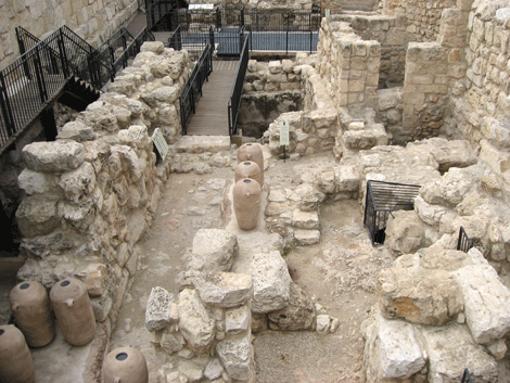
older palace in the City of David to the new McMansion. In the photo below, we are looking
at the floor of what archeologist Eilat Mazar calls
the late 10th century BC "Royal Structure." |
|
|
|
 |
|
Photo: Gila
Yudkin |
|
"Royal Structure" dated to late
tenth century BC, presumably built by Solomon |
|
|
|
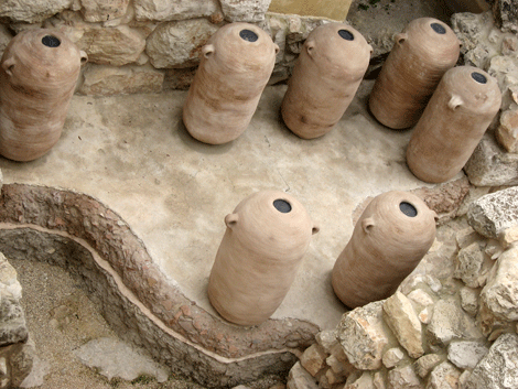
Twelve narrow-based very large cylindrical-shaped
clay jars called pithoi were found in two rooms in
the "Royal Structure." These jars are over
three feet tall and would be too large to carry, so
it's believed they were used as storage jars,
probably for liquids such as wine or oil. One
pithoi had a drawing of a date palm which may mean
that jar held date honey or date wine. Another
had an inscription. "belonging to the minister of
the ba-----" Eilat Mazar guesses that the
pithoi may have held foodstuff used by the royal
bakers. |
|
|
|
Note the two different floor levels in the photo
below. The top floor level with the red
clayish soil filled with lots of pottery was used
from the 8th century BC to the destruction of
Jerusalem by the Babylonians in 586 BC. The
bottom layer of light-brown earth is dated to the
latter part of the tenth century BC, the time of
King Solomon. One of the more important finds
was a round black juglet with a uniquely designed
handle purposely placed between the stones of the
structure, as if to "protect" it. |
|
|
|
 |
|
Photo: Gila
Yudkin |
|
Models of the 12 pithoi or
cylindrical-shaped clay storage jars |
|
|
|
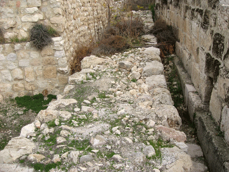
What Dr. Eilat Mazar calls the "Solomonic City Wall"
extends for over 70 yards and is dated by the
pottery found nearby. In the photo below, we
are looking towards the east and slightly north. |
|
|
|
 |
|
Photo: Gila
Yudkin |
|
Solomonic Wall perhaps mentioned
in First Kings 3 |
|
|
|
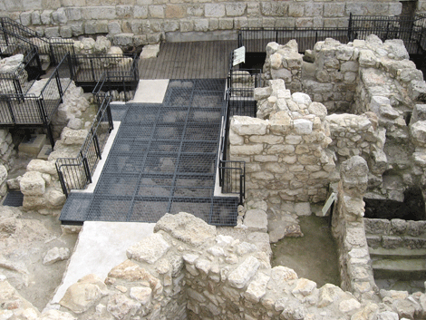
The four corners of the royal gatehouse were
oriented to the four points of the compass.
The gatehouse had four identical chambers and a
large approach tower. Unfortunately, much of
it is to be found under the modern road. In
the biblical period, the city gates were where the
action was: where people settled disputes,
where they came to request an audience with the
king, where they came to trade and exchange gossip.
Mazar suggests that this was called the Water Gate
in the time of Nehemiah (3:29). |
|
|
|
 |
|
Photo: Gila
Yudkin |
|
Looking down into two partially
preserved chambers of the royal gatehouse |
|
|
|
With all due respect to a virtual tour, it's much
more exciting to walk through the pages of the Bible
in person. Come to Jerusalem for
your
own biblical adventure! |
|
|
|
Shalom from Jerusalem, |
|
Gila Yudkin / December 21, 2011 |
|
|
|
Copyright December 2011 Gila Yudkin. Permission
needed for any reuse. |
| |
Coming to Jerusalem soon? Does the hustle and bustle of
the market give you a high, yet you would like some
quiet moments in the holy sites? Are you eager
to eat humus and knafe elbow-to-elbow with
the "natives," or is dining in the style of King
Solomon and the Queen of Sheba more to your taste?
Gila's Guide
will lift up your spirit as you "Explore
Jerusalem's Soul." This up-to-date PDF (Adobe Acrobat) 46-page
guide gives you the Top Ten places to meditate on
the Bible, the Top Ten lesser-known churches worth
visiting, the Top Ten most rewarding roof-top views
and the Top Ten places for yummy Middle Eastern soul
food. More on
Gila's Guide...
|

